Journal Articles
Machine learning model optimization for flood susceptibility zonation over the Kosi megafan
Authors: Arora, A.*, Durga G, P., Pandey, M. et al.
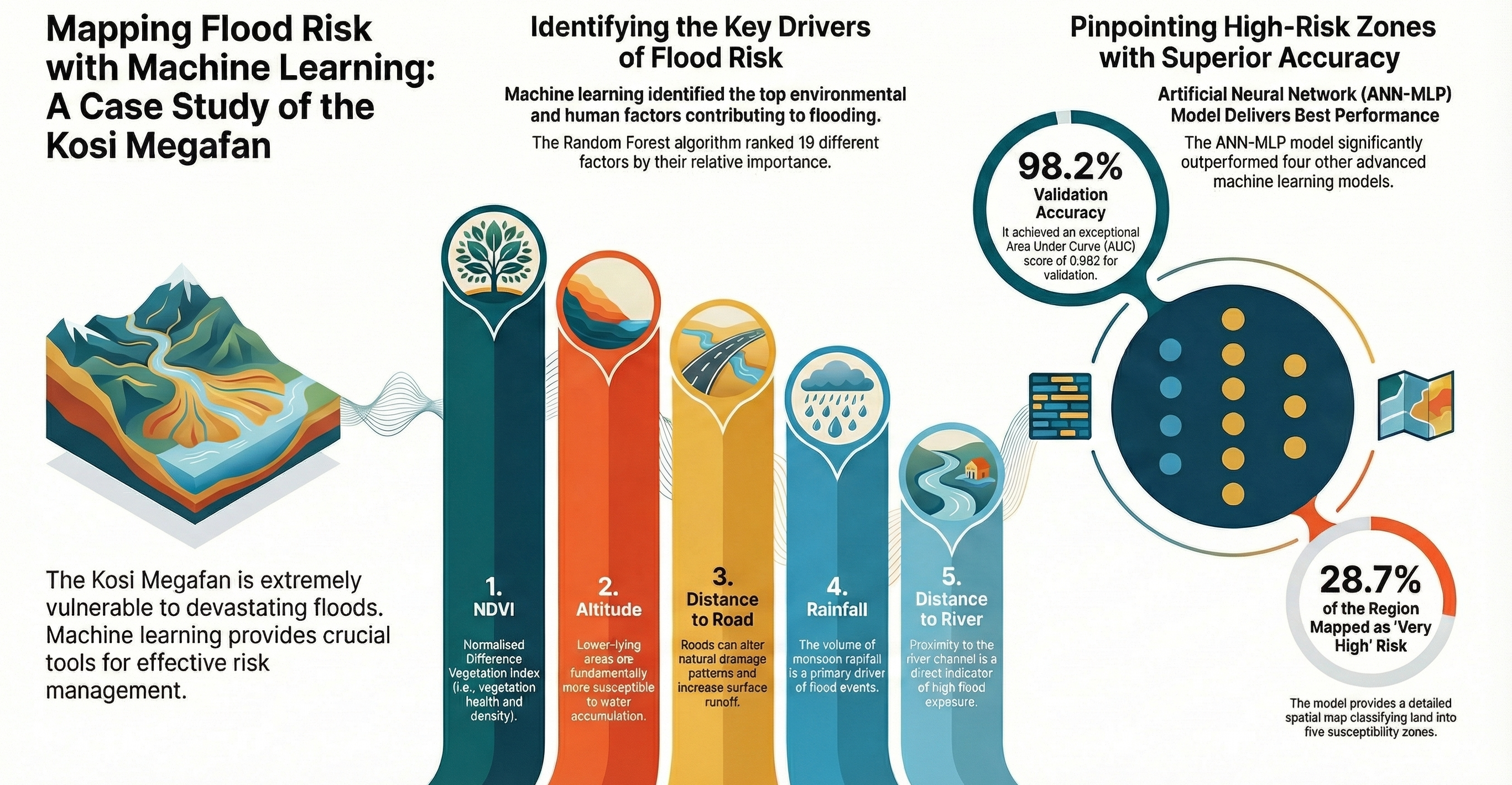
Optimized 5 ML algorithms to map flood risks. The ANN-MLP model achieved 98.2% accuracy, identifying that 28.7% of the region is at 'Very High' risk.
View DOI →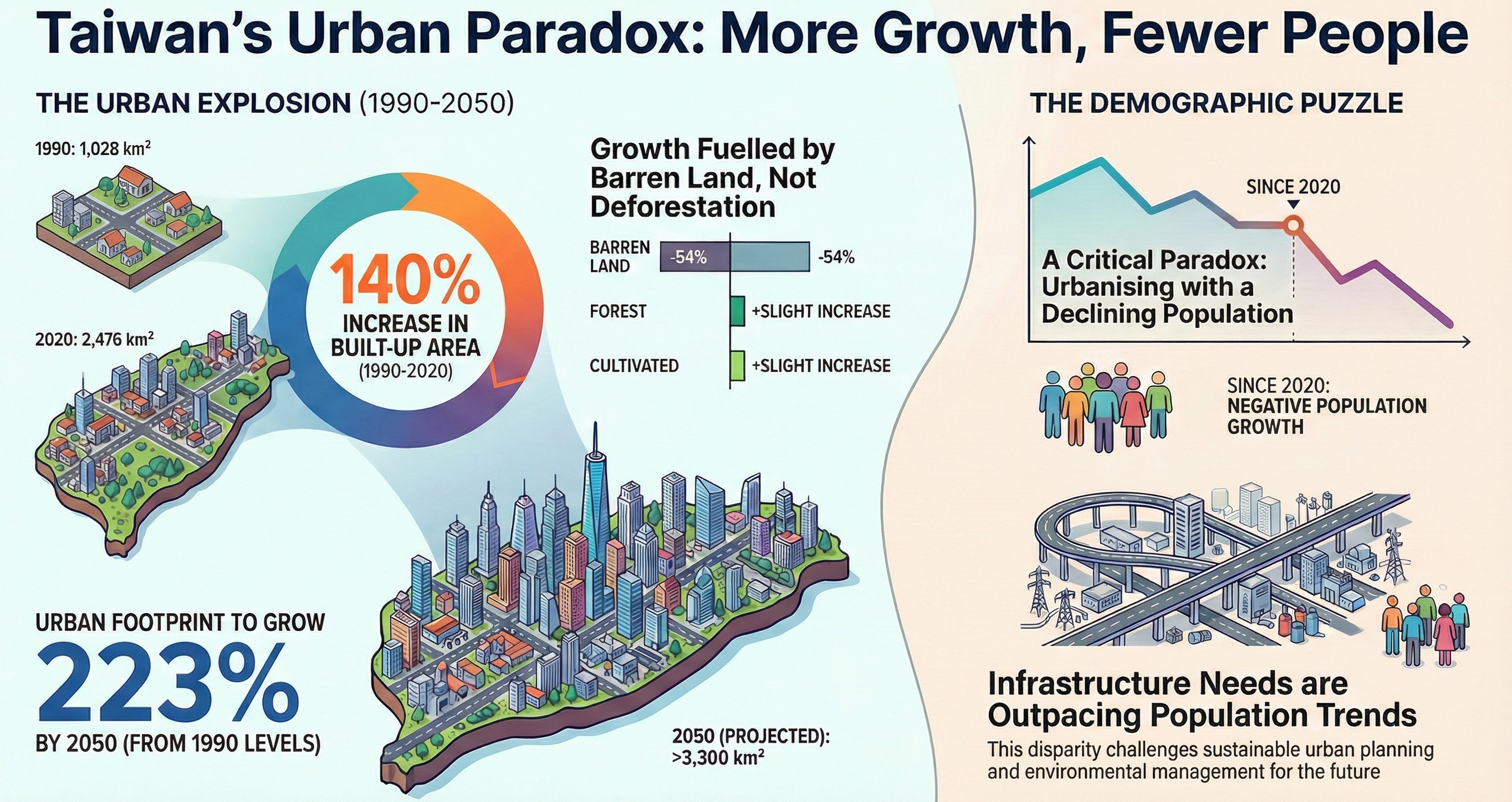
Decadal analysis and simulation of land use changes in Taiwan using ML and Markov chains
Authors: Liu, C., & Arora, A.*
Identified a critical urban paradox: a 140% increase in built-up area (1990-2020) despite a projected population decline.
View DOI →Landslide susceptibility assessment and mapping using new ensemble model
Advances in Space Research (2024)
Authors: Shen, Z., Wang, D., Arabameri, A., Santosh, M., Egbueri, J. C., & Arora, A.
View DOI →Earth fissure susceptibility mapping: Application of random subspace‐based novel ensemble approaches
Geological Journal (2024)
Authors: Santosh, M., Arabameri, A., & Arora, A.
View DOI →Landslide susceptibility mapping: application of novel hybridization of rotation forests (RF) and Java decision trees (J48)
Soft Computing, 27, 17387–17402 (2023)
Authors: Liang, L., Cui, H., Arabameri, A., Arora, A., & Seyed Danesh, A.
View DOI →Flood susceptibility prediction using multi criteria decision analysis and bivariate statistical models: a case study of Lower Kosi River Basin
Stochastic Environmental Research and Risk Assessment, 37, 1855–1875 (2022)
Authors: Arora, A.*
View DOI →Prediction of groundwater nitrate concentration in a semiarid region using hybrid Bayesian artificial intelligence approaches
Environmental Science and Pollution Research, 29, 20421–20436 (2022)
Authors: Alkindi, K. M., Mukherjee, K., Pandey, M., Arora, A., et al.
View DOI →Flood susceptibility modelling in a subtropical humid low-relief alluvial plain environment: Application of novel machine learning ensemble approach
Frontiers in Earth Science, 9, 659296 (2021)
Authors: Pandey, M., Arora, A.*, Arabameri, A., Costache, R., Lee, S.
View DOI →Comparative evaluation of geospatial scenario-based land change simulation models using landscape metrics
Ecological Indicators, 128, 107810 (2021)
Authors: Arora, A., Pandey, M., Mishra, V.N., et al.
View DOI →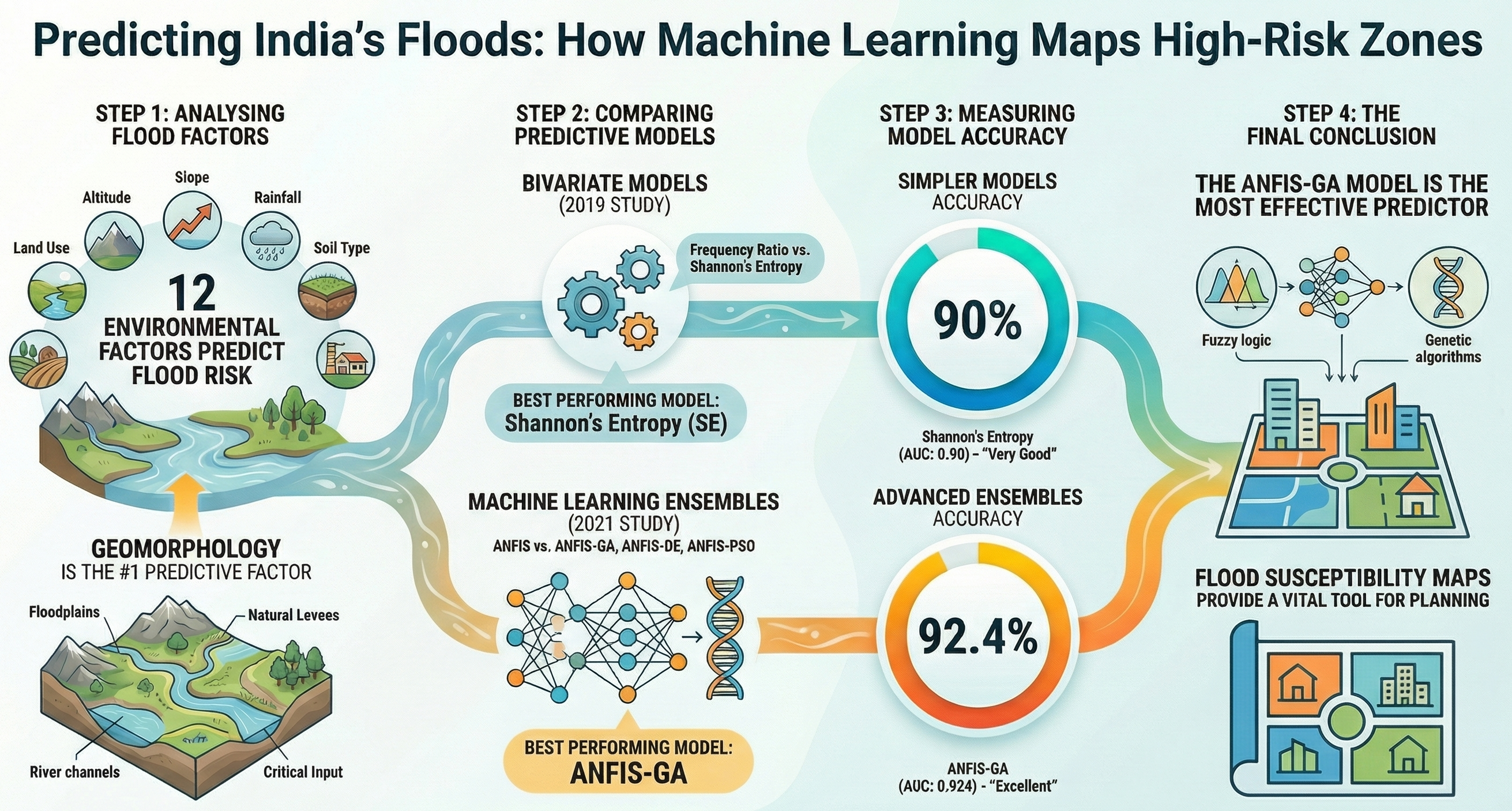
Optimization of State-of-the-Art Fuzzy-Metaheuristic ANFIS-Based Machine Learning Models
Authors: Arora, A., Arabameri, A., Pandey, M., et al.
The ANFIS-GA model proved to be the most effective predictor (92.4% accuracy), outperforming PSO and DE variants.
View DOI →
Flash-flood propagation susceptibility estimation using weights of evidence and their novel ensembles
Authors: Costache, R., ... Arora, A., et al.
This study establishes the Bivariate Statistical baselines (Frequency Ratio / Shannon's Entropy) referenced in the comparative analysis visual.
View Paper →Flood Susceptibility Assessment Using Novel Ensemble of Hyperpipes and Support Vector Regression Algorithms
Water, 13 (2), 1–27 (2021)
Authors: Saha, A., ... Arora, A., et al.
Climate Change Effect on Water Resources in Varanasi District, India
Meteorological Applications, 27 (1), 1–16 (2020)
Authors: Nistor, M. M., ... Arora, A., et al.
K-Fold and Metaheuristic Machine Learning Approaches for Groundwater Potential Modelling
Authors: Arabameri, A., Arora, A., et al.
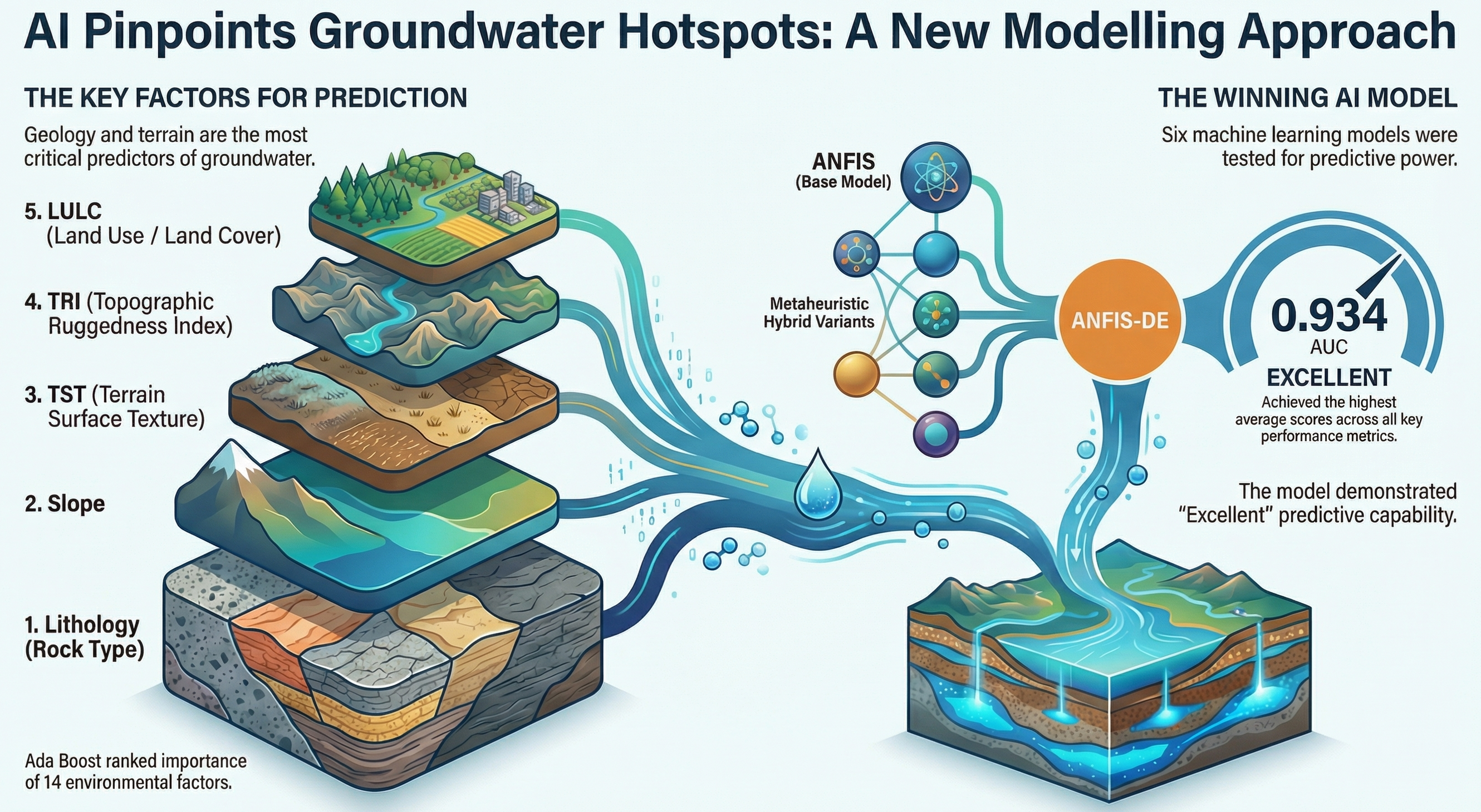
Developed the ANFIS-DE model which pinpointed groundwater hotspots with an excellent AUC score of 0.934.
Flood Susceptibility Mapping Using a Novel Deep Learning Model Combining Multilayer Perceptron and Autoencoder Neural Networks
Journal of Flood Risk Management, 14 (1) (2020)
Authors: Ahmadlou, M., ... Arora, A., et al.
Book Chapters & Editorials
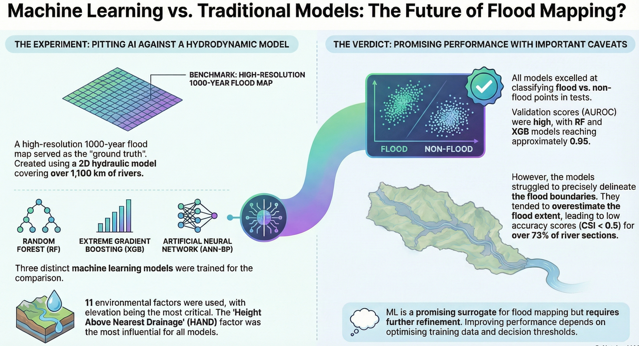
Evaluation of ML Approaches for Flood Hazard Mapping Over the Argens Basin, France
Authors: Arora, A.*, Nicolle, P., Payrastre, O.
A critical comparison of RF, XGB, and ANN against high-resolution hydrodynamic models (1000-year flood maps).
View Chapter →Linkage Between Forest Fires and Meteorological Parameters Using Spatial Clustering
Geo-Information for Disaster Monitoring and Management (2024)
Authors: Pandey, M., Arora, A.*, Geesupalli, P.
Co-Editor: Advances in Remote Sensing Technology and the Three Poles
Wiley Publications, USA (2022)
Co-edited the comprehensive volume and contributed to 4 chapters regarding Landscape Modeling, Spectral Indices, and Morphometry Software.
Statistical Analysis of Major Flood Events During 1980-2015 in Middle Ganga Plain
Spatial Information Science for Natural Resource Management, IGI Global (2020)
Authors: Arora, A., Siddiqui, M. A., & Pandey, M.